

Landforms and their Evolution
- Pratik Garg

- Mar 17, 2025
- 3 min read
Introduction
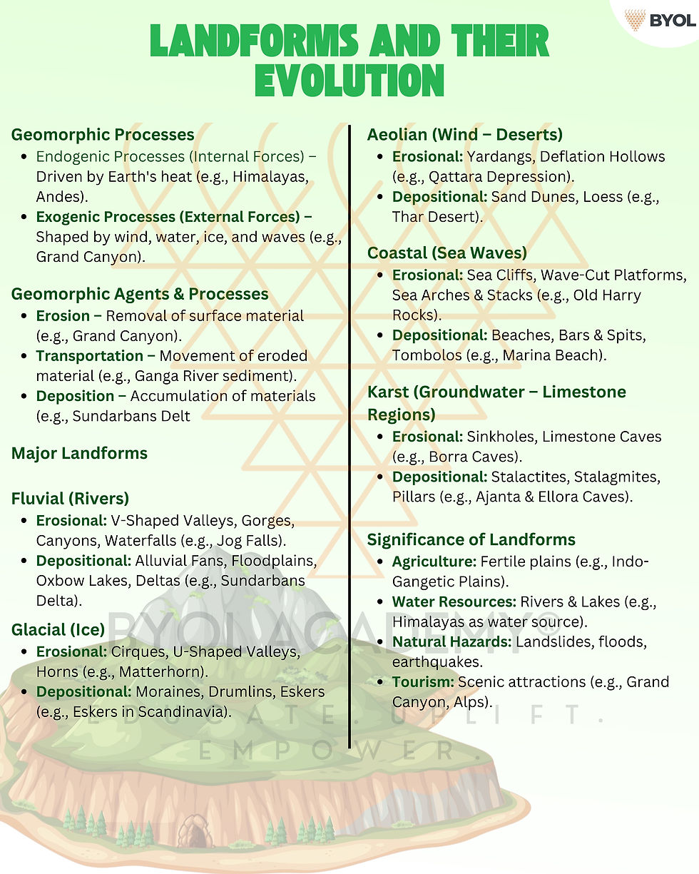
The Earth's surface undergoes continuous changes due to geomorphic processes, which result in different landforms.
Landforms: Natural features on the Earth's surface, shaped over time.
Two Types of Geomorphic Processes:
Endogenic Processes (Internal forces) – Driven by heat from Earth's interior.
Example: Tectonic movements leading to mountain formation (Himalayas, Andes).
Exogenic Processes (External forces) – Driven by external agents like wind, water, ice, and waves.
Example: Erosion by rivers creating valleys (Grand Canyon).
Geomorphic Agents and Processes
Geomorphic Agents: Running water, glaciers, wind, sea waves, and groundwater.
Processes Involved:
Erosion – Removal of surface material by agents like rivers, glaciers, wind.
Example: River erosion carving out the Grand Canyon, USA.
Transportation – Movement of eroded material by natural forces.
Example: Sediment carried by the Ganga River.
Deposition – Accumulation of eroded material in new locations.
Example: Formation of the Sundarbans delta.
Fluvial Landforms (Landforms by Running Water – Rivers)
Erosional Landforms by Rivers
V-Shaped Valleys:
Formed due to vertical erosion in youthful river stages.
Example: Indus River Valley in Ladakh.
Gorges:
Deep, narrow valleys formed by intense downcutting.
Example: Kali Gandaki Gorge in Nepal.
Canyons:
Larger and wider than gorges, with steep sides.
Example: Grand Canyon, USA (formed by the Colorado River).
Waterfalls:
Formed where a river flows over resistant rock layers.
Example: Jog Falls, Karnataka (Sharavati River).
Depositional Landforms by Rivers
Alluvial Fans:
Cone-shaped deposits formed at foothills.
Example: Himalayan foothills (where rivers like the Kosi deposit sediments).
Floodplains:
Flat plains created by seasonal floods depositing silt.
Example: Indo-Gangetic Plains.
Oxbow Lakes:
Crescent-shaped lakes formed by river meandering.
Example: Lakes along the Mississippi River, USA.
Deltas:
Triangular landforms at river mouths due to sediment accumulation.
Example: Sundarbans Delta (Ganga-Brahmaputra River System).
Glacial Landforms (Landforms by Moving Ice – Glaciers)
Erosional Landforms by Glaciers
Cirques:
Bowl-shaped depressions at mountain tops.
Example: Cirques in the Alps.
U-Shaped Valleys:
Glaciers erode valleys into a U-shape with steep sides.
Example: Glacier National Park, USA.
Horns:
Sharp, pyramid-like peaks formed by erosion from multiple glaciers.
Example: Matterhorn, Alps.
Depositional Landforms by Glaciers
Moraines:
Glacial debris (rocks, soil) deposited by melting glaciers.
Example: Terminal moraines in the Himalayas.
Drumlins:
Smooth, egg-shaped hills formed by glacial deposits.
Example: Drumlin fields in Canada.
Eskers:
Sinuous ridges of sand and gravel left by meltwater streams beneath glaciers.
Example: Eskers in Scandinavia.
Aeolian Landforms (Landforms by Wind – Common in Deserts)
Erosional Landforms by Wind
Yardangs:
Long, narrow ridges sculpted by wind erosion.
Example: Yardangs in the Lut Desert, Iran.
Deflation Hollows:
Depressions created by wind removing loose material.
Example: Qattara Depression, Egypt.
Depositional Landforms by Wind
Sand Dunes:
Hills of sand deposited by wind movement.
Example: Thar Desert (Rajasthan, India).
Loess:
Fine dust deposits carried by wind over large areas.
Example: Loess Plateau, China.
Coastal Landforms (Landforms by Sea Waves – Coastal Areas)
Erosional Landforms by Waves
Sea Cliffs:
Vertical rock faces formed by wave erosion.
Example: White Cliffs of Dover, UK.
Wave-Cut Platforms:
Flat areas left behind after wave erosion.
Example: Wave-cut platforms along the California coast, USA.
Sea Arches and Stacks:
Erosion forms caves, then arches, which eventually collapse into stacks.
Example: Old Harry Rocks, UK.
Depositional Landforms by Waves
Beaches:
Sandy or pebbly shorelines formed by wave deposition.
Example: Marina Beach, Chennai.
Bars and Spits:
Narrow ridges of sand formed by wave action.
Example: Chilika Lake Spit, India.
Tombolos:
Deposits connecting islands to the mainland.
Example: St. Michael’s Mount, UK.
Karst Landforms (Landforms by Groundwater – Common in Limestone Areas)
Formed due to chemical weathering of limestone (carbonation).
Erosional Karst Landforms
Sinkholes:
Circular depressions due to limestone dissolution.
Example: Great Blue Hole, Belize.
Limestone Caves:
Underground caves formed by dissolved limestone.
Example: Borra Caves, India.
Depositional Karst Landforms
Stalactites:
Icicle-like formations hanging from cave ceilings.
Stalagmites:
Pillar-like formations rising from the cave floor.
Pillars:
Formed when stalactites and stalagmites join.
Example: Ajanta & Ellora Caves, India.
Significance of Landforms
Agriculture – Fertile floodplains (e.g., Indo-Gangetic Plains).
Water Resources – Rivers, lakes (e.g., Himalayas as water sources).
Natural Hazards – Landslides, floods, earthquakes.
Tourism – Attraction sites (e.g., Grand Canyon, Alps).


Comments