

Distribution of Oceans and Continents
- Pratik Garg

- Mar 10, 2025
- 4 min read
Continental Drift Theory
Proposed by Alfred Wegener (1912):
Suggested that all continents were once part of a single supercontinent called Pangaea.
Pangaea broke apart around 200 million years ago, forming two large continents:
Laurasia (Northern hemisphere).
Gondwanaland (Southern hemisphere).
Continents drifted to their current positions over millions of years.
Evidence Supporting Continental Drift:
Jigsaw Fit: Coastlines of continents like South America and Africa fit together.
Fossil Evidence: Similar fossils of plants and animals found on different continents (e.g., Mesosaurus in South America and Africa).
Rock Formations: Similar mountain ranges and rock types on different continents (e.g., Appalachian Mountains and Caledonian Mountains).
Paleoclimatic Evidence: Evidence of ancient glaciers in regions like India, Australia, and South America, suggesting they were once located near the South Pole.
Limitations of the Theory:
Wegener could not explain the mechanism behind the movement of continents.
Critics argued that the forces required to move continents were not adequately explained.
Convectional Current Theory
Proposed by Arthur Holmes in the 1930s.
Suggested that convectional currents in the mantle are responsible for the movement of continents.
These currents are generated due to radioactive decay in the Earth's interior, causing heat and magma to rise and fall.
Seafloor Spreading Theory
Proposed by Harry Hess in the 1960s.
Key Concepts:
The ocean floor is not permanent; it is constantly being renewed.
Magma rises from the mantle at mid-oceanic ridges, creating new oceanic crust.
The old crust is destroyed in trenches (subduction zones).
Evidence:
Age of Rocks: Rocks near mid-ocean ridges are younger, while those near trenches are older.
Magnetic Stripes: Symmetrical patterns of magnetic stripes on either side of mid-ocean ridges indicate periodic reversals of Earth's magnetic field.
Plate Tectonics Theory
Definition: The Earth's lithosphere is divided into several tectonic plates that float on the semi-fluid asthenosphere.
Types of Plate Boundaries:
Divergent Boundaries: Plates move apart (e.g., mid-ocean ridges).
Convergent Boundaries: Plates collide (e.g., Himalayas formed by the collision of the Indian and Eurasian plates).
Transform Boundaries: Plates slide past each other (e.g., San Andreas Fault).
Forces Driving Plate Movements:
Mantle convection currents.
Ridge push and slab pull forces.
Significance:
Explains the formation of mountains, earthquakes, and volcanoes.
Helps understand the distribution of continents and oceans.
Evolution of Continents and Oceans
Pangaea (250 million years ago):
Single supercontinent surrounded by a single ocean called Panthalassa.
Breakup of Pangaea:
Formed Laurasia and Gondwanaland.
Further breakup led to the formation of modern continents.
Tethys Sea:
A shallow sea between Laurasia and Gondwanaland.
Remnants include the Mediterranean Sea, Black Sea, and Caspian Sea.
Distribution of Earthquakes and Volcanoes
Earthquakes:
Concentrated along plate boundaries (e.g., Pacific Ring of Fire).
Pacific Ring of Fire is explained in volcanism notes
Caused by tectonic plate movements.
Volcanoes:
Found at divergent and convergent boundaries.
Examples: Mid-Atlantic Ridge, Andes Mountains.
Major Ocean Basins
Pacific Ocean: Largest and deepest ocean.
Atlantic Ocean: S-shaped, with a mid-ocean ridge.
Indian Ocean: Smaller and younger than the Pacific and Atlantic.
Southern Ocean: Surrounds Antarctica.
Arctic Ocean: Smallest and shallowest.
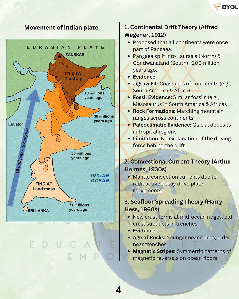
Movement Of Indian plate
Introduction
The Indian Plate was originally part of the Gondwanaland supercontinent.
Over millions of years, it has moved northward, leading to the formation of the Himalayas and shaping the Indian subcontinent.
Geological Background
Tectonic Setting: The Indian Plate is a minor plate within the Indo-Australian Plate, which also includes the Australian Plate.
Plate Boundary Types:
Convergent (Destructive): Collision with the Eurasian Plate.
Divergent (Constructive): Separation from the Antarctic Plate.
Transform (Conservative): Horizontal movements along boundaries.
Phases of Indian Plate Movement
A. Breakup from Gondwanaland (~150 million years ago)
India was once part of Gondwanaland, along with Africa, Australia, Antarctica, and South America.
Due to convection currents, Gondwanaland started splitting in the Jurassic Period (~150 million years ago).
B. Northward Drift (~100-80 million years ago)
The Indian Plate detached from the African Plate and started moving northward at a rapid pace (~15-20 cm/year).
The Tethys Sea existed between India and Eurasia during this time.
C. Collision with the Eurasian Plate (~40-50 million years ago)
As the Indian Plate approached Eurasia, the Tethys Sea started closing.
Around 50 million years ago, the Indian Plate collided with the Eurasian Plate, leading to:
Subduction of the Tethys Sea.
Upliftment of sediments, forming the Himalayas.
Volcanic activity and earthquakes in the region.
D. Post-Collision Slowdown (~Present Day)
The Indian Plate continues to move northward at ~5 cm/year.
This movement causes:
Ongoing rise of the Himalayas (~5 mm/year).
Seismic activity in the Himalayas and Indo-Gangetic plains (e.g., earthquakes in Nepal, Kashmir).
Impact of Indian Plate Movement
Geophysical Consequences
Formation of Himalayas: The world’s youngest fold mountains.
Seismic Activity: Frequent earthquakes (e.g., 2001 Bhuj, 2015 Nepal quake).
Tibetan Plateau: Uplift due to crustal compression.
Climatological Impact
Monsoon System: Himalayas block cold winds, intensifying the Indian monsoon.
River Systems: Major rivers like Ganga, Brahmaputra originate due to Himalayan uplift.
Environmental and Economic Aspects
Landslides: Due to continued uplift and seismic activity.
Infrastructure Challenges: High seismic risk in Northern India.
Mineral Resources: Himalayan uplift has exposed various minerals and fossil fuels.


Comments